


- Adventure, Ecological, Sightseeing, Wildlife
Hike To Mount Kilimanjaro - Machame Route
- Moshi, Tanzania
- English, French
Description
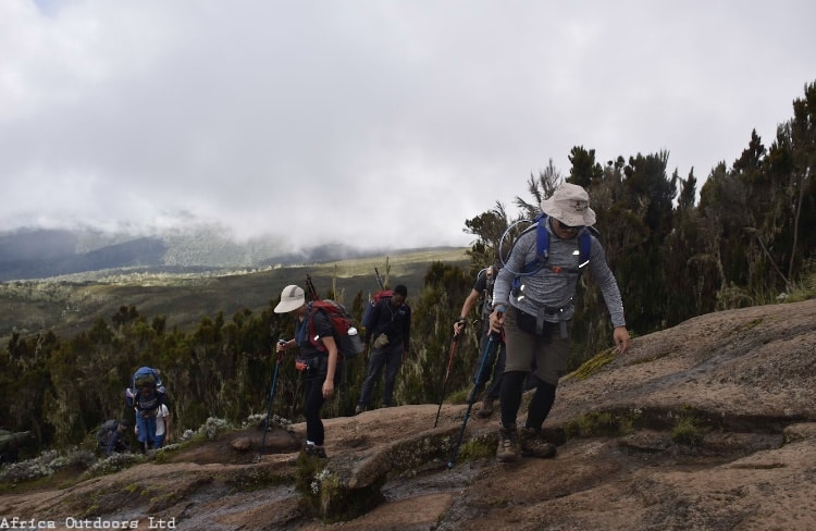
The Machame route to Mount Kilimanjaro is one of the most popular routes for hikers. It’s a beautiful and challenging hike that takes you through a variety of landscapes, from lush rainforest to rocky alpine desert. The route is known as the “Whiskey” route, due to its difficulty level. The hike usually takes around 6-7 days, with each day involving around 5-7 hours of hiking. The final ascent to the summit is done at night, so hikers can watch the sunrise from the top of the mountain. The views from the top are breathtaking and make the entire hike worth it.
Highlights
- Machame Camp
- Shira Camp
- Lava Tower
- Barranco Camp
- Barafu Hut
- Summit and Mweka Camp
- Mweka Gate
What's Included
- 2 nights accommodation while in Moshi town
- Meals during hike
- High quality camping equipment
- Experienced and professional guides
- Pulse oximeter for daily checks
- Airport transfers
- Park fees
What's Excluded
- International flights and visa
- Insurance
- Tips for guides and other staff
- Meals while in Moshi town
Itinerary
Day 0 Kilimanjaro Airport to hotel
If you have opted for the optional airport transfers, we will pick you up from Kilimanjaro Airport or Arusha airport and transfer you to your hotel in Moshi. Pre-trek briefing at your Moshi hotel. You should be planning to arrive at least one day before the start of the trek. Today we will spend in having a pre-trek briefing. We will also review your equipment and rent any equipment which is needed.
Day 1 Hotel to Machame Camp
Drive from Moshi to Machame Gate takes about 45 minutes. The journey passes through the village of Machame which is located on the lower slopes of the mountain. We depart the park gate and walk through the rain forest on a winding trail up a ridge. At lower elevations the trail can be muddy and slippery. Gaiters and trekking poles are a good idea here. We continue a short distance until we reach the Machame Camp. Elevation: 1830m/6000ft to 3050m/9950ft Distance: 11km/7mi Hiking Time: 5-6 hours Habitat: Montane Forest Meals: Lunch and Dinner
Day 2 Machame Camp to Shira Camp
After breakfast we leave the glades of the rain forest and continue on an ascending path, crossing the valley along a steep rocky ridge. The route now turns west onto a river gorge until we arrive at the Shira campsite. Elevation: 3050m/9950ft to 3850m/12,600ft Distance: 5km/3mi Walking Time: 4-5 hours Habitat: Moorland Meals: Breakfast, Lunch and Dinner
Day 3 Shira Camp to Lava Tower to Barranco Camp
From the Shira Plateau we continue to the east up a ridge, passing the junction towards the peak of Kibo. As we continue, our direction changes to the South East towards the Lava Tower, called the “Shark’s Tooth” (elev4650m/15,250ft). Shortly after the tower we come to the second junction which goes to the Arrow Glacier. We now continue down to the Barranco Camp. Although you end the day around the same elevation as when you began, this day is very important for acclimatization and will help your body prepare for summit day. Elevation: 3850m/12,600ft to 4000m/13,000ft Distance: 10km/6mi Walking Time: 5-6 hours Habitat: Semi-desert Meals: Breakfast, Lunch and Dinner
Day 4 Barranco Camp to Barafu Camp
After breakfast, we leave Barranco and continue on a steep ridge up the Barranco Wall (4250m/13,900ft), through the Karanga Valley (4050m/13,250ft) to the junction which connects with the Mweka Trail. We continue up to the BarafuCamp. You have completed the South Circuit, which offers views of the summit from many different angles. Here we make camp with views of the summit in the distance. Elevation: 4000m/13,000ft to 4700m/15,350ft Distance: 9km/6mi Hiking Time: 6-8 hours Habitat: Alpine Desert Meals: Breakfast, Lunch and Dinner
Day 5 Barafu Camp to Summit to Mweka Camp
Very early in the morning (midnight to 2 am), we continue our way to the summit between the Rebmann and Ratzel glaciers. You head in a north-westerly direction and ascend through heavy scree towards Stella Point on the crater rim. This is the most mentally and physically challenging portion of the trek. At Stella Point you will stop for a short rest and will be rewarded with the most magnificent sunrise you are ever likely to see. Faster hikers may view the sunrise from the summit. From Stella Point, you may encounter snow all the way on your 1-hour ascent to the summit. Once at Uhuru Peak you have reached the highest point on Mount Kilimanjaro and the continent of Africa! From the summit we begin our descent by continuing straight down to the Mweka Camp, stopping at Barafu for lunch. You may want gaiters and trekking poles for the loose gravel going down. We arrive at Mweka Camp and enjoy our last evening on the mountain. Elevation: 4700m/15,350ft to 5895m/19,340ft Down to 3090m/10,150ft Distance: 5km/3mi up / 13km/8mi down Hiking Time: 5-7 hours up / 5-6 hours down Habitat: Stone scree and ice-capped summit Meals: Breakfast, Lunch and Dinner
Day 6 Mweka Camp to Mweka Gate to Hotel
After breakfast we continue the descent down to the Mweka Park Gate to receive your summit certificates. At lower elevations, it can be wet and muddy. Gaiters and trekking poles will help. Shorts and t-shirts will probably be plenty to wear (keep rain gear and warmer clothing handy). Africa Outdoors vehicle will be waiting for you at Mweka gate to drive you back to your hotel in Moshi (around 60 minutes). Elevation: 3090m/10,150ft to 1680m/5500ft Distance: 10km/6mi Hiking Time: 3-4 hours Habitat: Forest Meals: Breakfast
